
Monday, 27 March 2006.
On Saturday, 25 March, 2006, the Canadian Transportation Safety Board seized the Queen Of The North for purposes of its investigation. That is a normal procedure for a disaster of this magnitude. What that means is that the TSB now effectively has control of the vessel, the bottom she rests upon, the water column, the surface and all surrounding waters. Access to the site is at TSB discretion and all materiel gained by access goes directly to the TSB.
It should be kept in mind that the TSB is not in the business to "assign fault or determine civil or criminal liability".
The TSB has interviewed crew members and have made the determination that mechanical failure was not the cause of QOTN hitting Gil Rock. (CBC report). What makes this an even more interesting statement is that the TSB made that determination without actually having seen the vessel. More on that shortly.
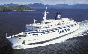
The site was surveyed yesterday by a manned submersible. The ship was found in 427 meters (1388 feet) of water resting in an upright position, in one piece. She is in deep silt which is up to the rubbing strake and in some cases, over the rubbing strake.
What that means is that the part of the hull normally underwater is not visible, and that means there is no way to see the actual damage without either raising the ship, turning it over or excavating the silt around her. Given the depth, none of that is likely to be attempted very soon.
From interviews with passengers and crew the TSB has been able to determine that the ship hit Gil Rock on the ship's starboard side (right hand side when looking forward), and it was probably torn open from the bow all the way to the stern; literally the entire length of the ship.
Weather may have been a factor. The ship was experiencing high winds and rain squalls at the time of the accident. However, that is not unusual weather in that area at that time of year and crews on that run are quite used to dealing with it.
The pictures taken by the mini-sub have been sent to TSB headquarters in Ottawa for analysis and it is very unlikely the public will get to see them for quite some time. There will be attempts to recover the electronic charting system (ECDIS) from the bridge of the ship. The ECDIS, aside from being a navigation device, acts as something similar to a bridge data recorder. It retains a history and any course and speed changes will be recorded as they occurred. It also has the ship's intended track, if it was inserted, which may determine the actual distance off-track the ship might have been at the time of hitting Gil Rock.
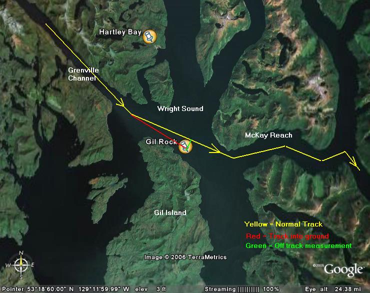 All that taken into account, the ship was a good 1/2 nautical mile (1 kilometer) to the right of her normal track in that spot. (Click on the picture for a larger image.)
Interviews with the crew would have immediately been conducted with the officer of the watch (in control of the ship), the engineering officer of the watch (in control of machinery, steering gear, etc.) and the helmsman (steering under orders from the officer of the watch). From those initial interviews, the TSB determined that there was no mechanical failure which led to the QOTN hitting Gil Rock.
There has been a call to have the TSB declare that it was human error. They cannot do that at this point. Without complete bridge data there is no way to determine whether there was an instrument error or whether the officer of the watch actually had a grasp of his/her position.
Some factors:
The presence of rain squalls presents a radar problem. Dense squalls show up as a near solid object on X-band marine radars and might have obscured the shoreline of Gil Island, or even the lead mark into MacKay Reach.
Wind, depending on direction may have set the ship further to the south than the oow wanted, but that is correctable. Further, if weather conditions are causing problems the first reaction would be to slow down. QOTN appears to have hit Gil Rock at full speed (19 knots).
GPS error. The ECDIS navigation system is fed information from several sources. The Automated Radar Plotting Aid (ARPA) provides real-time surface data and the Global Positioning System provides near real-time position fixing. The problem with relying soley on these systems is that accuracy, while normally reliable, can be affected by a multitude of things. As I always tell my trainees, that is why the bridge has lots of windows.
For now, all we can do is speculate and that will not provide the answer to why this horrible event took place.
For what it's worth, it was a disastrous weekend for the global merchant marine. Not only did we have our own deadly accident on the BC coast, but a ferry sank in Cameroon with a huge loss of life and the cruise ship Star Princess had a fire which killed one person and injured 11.
No comments:
Post a Comment