I have reversed those two cyclones alphabetically because of the inherent threats each one represents. TS Lisa has been with us for a while but remains a weak system and presents less risk to population. Matthew developed overnight and is now the subject of Hurricane Warnings and Watches in Central America.
Tropical Storm Matthew is something of a guessing game at the moment. Track models vary significantly. Because of this the intensity forecast is also very thready since the route Matthew takes will have an effect on its intensity.
Matthew has been given an initial intensity of 45 knots (83 kmh/52 mph) keeping it well below hurricane strength for the time being. It is located 170 miles (275 km) East-Southeast of the Nicaragua/Honduras border, tracking in a westerly direction at 14 knots (26 kmh/16 mph). The cyclone will probably track West-Northwest and slow somewhat over the next day or two. After that the official forecast is that this cyclone will start to track North into the Gulf of Mexico. The NHC gives that forecast a low confidence. None of the intensity models have Matthew becoming a hurricane before making landfall however, caution suggests that hurricane preparations for Nicaragua and Honduras are prudent.
Hurricane Warnings are flying for Puerto Cabezas Nicaragua to Limon Honduras including the offshore islands.
Hurricane Watch is in effect for the coast of Belize.
Tropical Storm Warnings have been issued for Limon Honduras westward to the Guatemala border.
Tropical Storm Lisa presents no threat to population although there is some risk to shipping. Located about 295 miles (475 km) Northwest of the Cape Verde Islands, Lisa is tracking Northeastward at 4 knots (7 kmh/5 mph). Max sustained winds are 35 knots (65 kmh/40 mph).
Lisa is expected to move northward and weaken as it comes under the influence of increased wind shear.
Showing posts with label tropical depressions. Show all posts
Friday, September 24, 2010
Tuesday, September 14, 2010
Tropical Storm Karl

Add one more to the mix. The US National Hurricane Center hasn't issued anything publicly at the time of writing but the US Navy Fleet Numerical Meteorology and Oceanography Center has named the disturbance in the western Caribbean Tropical Storm Karl.
This system located about 300 miles east of Chetumal Mexico and is tracking West-Northwest at about 13 knots (24 kmh/15 mph).
Expect Tropical Storm warnings to be issued for the Yucatan, Belize, the Cayman Islands, Jamaica and Cuba.
Labels:
hurricanes,
karl,
tropical depressions
Monday, September 13, 2010
Hurricane Igor and Tropical Storm Julia
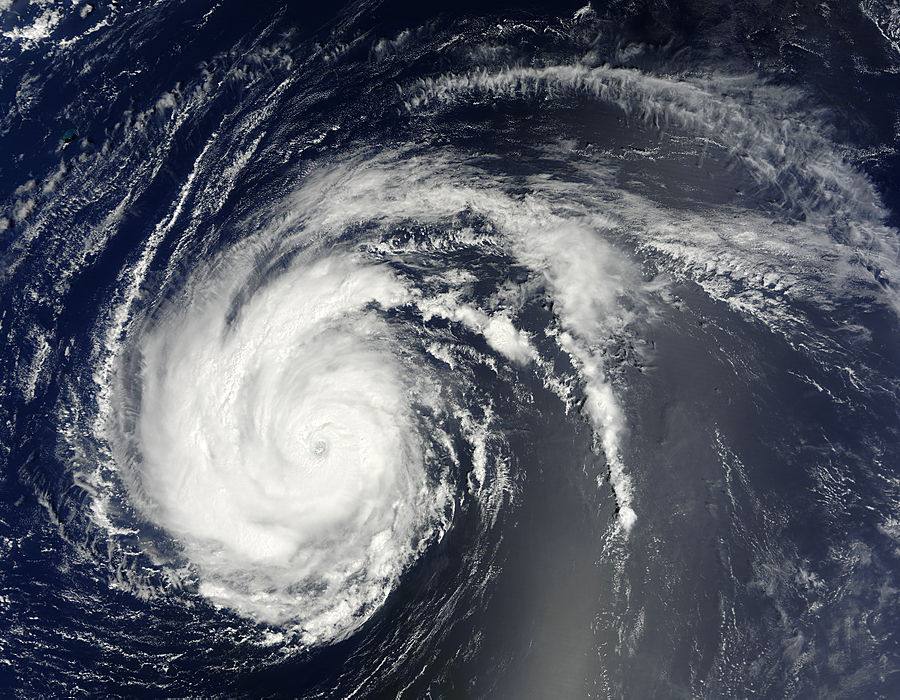
It took a while for Igor to develop in the tropical eastern Atlantic but now, with some extraordinarily high sea surface temperatures and minimal wind shear, this cyclone has reached the upper limit of Category 4 on the Saffir-Simpson Wind Scale and is now a major hurricane. Official NHC guidance is that Igor will not reach Category 5 although that depends on some changing upper air conditions. Most intensity forecasts show support a system that will strengthen today and then gradually weaken as it undergoes eyewall replacement. Some intensity models suggest Igor will indeed become a Cat 5 cyclone.
Igor is located about 940 miles/1500 miles east of the Leeward Islands of the Lesser Antilles tracking westward at 11 knots (20 kmh/13 mph). It packs sustained winds of 130 knots (241 kmh/150 mph). Most models are in agreement that Igor will start to slow its forward progress somewhat and start to adopt a track tendency north of west. That will see the cyclone move slightly poleward before it has a significant impact on the Lesser Antilles. It is far too early to forecast where Igor will become a major threat to population although at least three models suggest a probability of Igor making a pass over Bermuda as a major hurricane.
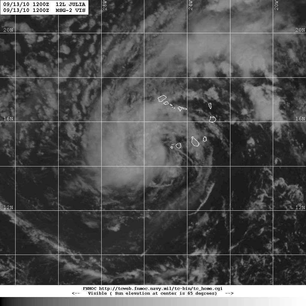
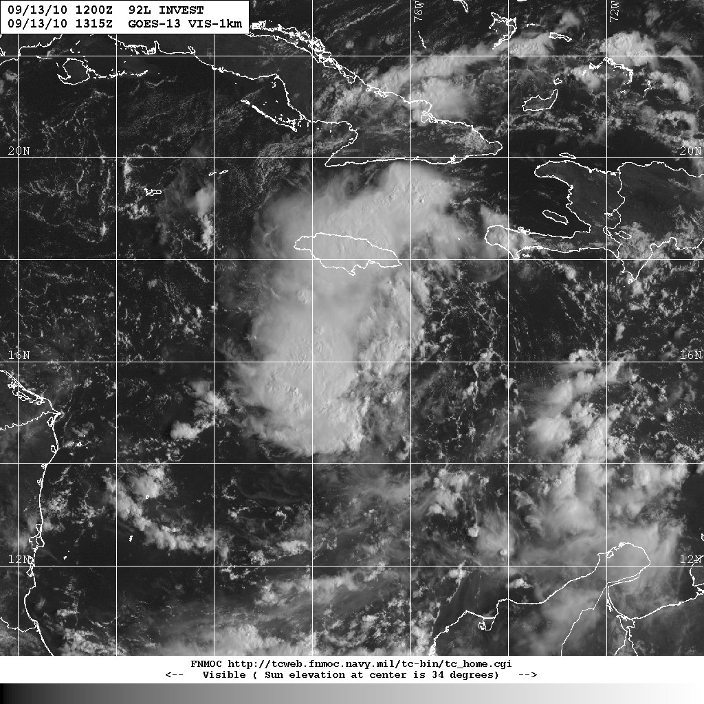
Tropical Storm Julia is located about 85 miles WSW of the Cape Verde Islands. Initially a bit difficult to pin down, Julia is tracking West-Northwest at about 11 knots (20 kmh/13 mph). Sustained wind speeds are estimated at around 35 knots (65 kmh/40 mph). Julia is not expected to intensify over the next two days, however there is some significant divergence in the forecast models. The current prognosis is that Julia will move further to the north and intensify by mid-week.We're also watching this somewhat disorganized cloud formation created by a trough of low pressure over the central Caribbean, designated 92L.
Labels:
hurricanes,
igor,
Julia,
tropical depressions
Thursday, September 02, 2010
Hurricane Earl, Tropical Storm Fiona and Tropical Depression Gaston - 021400Z
Hurricane Earl, an intense category 4 cyclone, is now about 300 miles south of Cape Hatteras. The storm is moving north at about 16 knots (30 kmh/18 mph). It is packing sustained winds of 125 knots (232 kmh/144 mph). The centre of Earl is expected to be abeam the North Carolina Outer Banks by tonight. Sometime in the next 8 hours Earl should peak in intensity. The ocean buoy at Diamond Shoals is showing a significant increase in wave height, dropping sea level pressure and increasing ENE winds.The NHC has issued Hurricane Warnings for North Carolina from Bogue Inlet northeastward to the NC/Virginia border with Hurricane Watch and Tropical Storm Warnings or watches along a majority of the US east coast. (Click the link for details).
The Canadian Hurricane Centre has issued a Tropical Storm Watch for Yarmouth, Shelburne and Queens Counties in Nova Scotia. (Port Maitland to Medway Harbour)
Earl is now moving around the western edge of the subtropical ridge and will encounter the base of the Westerlies in about 24 hours. An upper trough moving out of the Great Lakes will interact with this cyclone causing it to accelerate its speed of advance as it begins to track more toward the northeast.
For the Canadian Maritimes the problem is high air temperatures over the region and sea surface temperatures that are as much as 4 degrees Celsius higher than normal. There is a possibility that Earl will retain its tropical features as it approaches the Nova Scotia coast. Earl will likely arrive at the Canadian Maritime coast early Saturday morning, somewhere between the New Brunswick Fundy shore and the South Shore of Nova Scotia.
TS Fiona is tracking north-northwest at 15 knots. This storm is challenged by a lot of northerly wind shear. While it still has sustained wind speeds of 45 knots (83 kmh/52 mph) it is expected to weaken in the next 36 hours and dissipate by late Sunday.
A Tropical Storm Warning is in effect for Bermuda as Fiona's current track takes the cyclone directly through that island late Friday or early Saturday morning.Tropical Depression Gaston is one to watch after Earl passes. It was downgraded as a result of the lower intensity winds estimated in its centre. However, it is in a position where conditions will exist to allow strengthening in the next 96 hours although that will be fairly slow. Gaston is moving slowly towards the west at about 6 knots (11 kmh/7 mph). This slow advance will give Gaston time to develop once the upper air conditions change.
Labels:
earl,
fiona,
gaston,
hurricanes,
tropical depressions
Wednesday, September 01, 2010
Hurricane Earl, Tropical Storm Fiona and Tropical Storm Gaston - 012100Z
Hurricane Earl is tracking towards the northwest at about 15 knots. At present the outer edges of the wind field are just east of Abaco in the Bahamas. Maximum sustained winds are about 115 knots (213 kmh/132 mph). Hurricane warnings have been issued for the North Carolina coast. Conditions suggest that Earl will restrengthen to category 4, possibly by later today. The coastal area under a Hurricane Warning can expect a destructive storm surge in the range of 3 to 5 feet above ground level. The swells being generated ahead of Earl have already started to reach the Bahamas as can be seen on this Abaco webcam. Large swells will begin to hit the US east coast shortly.
As Earl reaches the edge of the subtropical ridge it should start recurving more to the north-northwest and then north, possibly as early as tonight. As Earl encounters the Westerlies it should start to turn out towards the east by Friday morning. All the models seem to support this and the NHC is issuing that guidance. Earl should weaken in intensity but increase the speed of its advance as it encounters greater wind shear. If there's a problem it is the record warm waters it will encounter as it leaves the tropics. The Gulf Stream is certainly warmer than it has ever been and it is providing enough sea surface temperature to support a hurricane.Models produce a small westward adjustment of Earl's track. That continues to suggest that Earl will make landfall somewhere between Maine and the South Shore of Nova Scotia, most likely with Tropical Storm force. (This could create a massive surge in the Bay of Fundy.)
TS Fiona is a small Tropical Storm with sustained winds of 50 knots (93 kmh/58 mph). The cyclone is showing tropical storm force winds with a radius of only 100 miles around it.
Fiona is tracking towards the northwest at about 17 knots. That's still pretty fast and most models suggest that Fiona will continue in that direction but begin to slow significantly. Intensity at this point is a touch call, however, the cyclone should be influenced by Earl in the next two days which should put the cyclone into the decay stage.
TS Gaston is in the centre of the tropical Atlantic moving slightly north of westward at 13 knots. Initial intensity is sustained winds of 35 knots (65 kmh/40 mph). Gaston will encounter a couple of conditions which will challenge development: There is a considerable amount of dry air to the west and north of it; and, the weakening subtropical ridge will cause it to slow. Most models show Gaston becoming a hurricane within the next 5 days.
As always, click any image to enlarge.
Added: A look at the Atlantic this evening with the named storms identified.

Labels:
earl,
fiona,
gaston,
hurricanes,
tropical depressions
Monday, August 30, 2010
Hurricane Earl. Brace yourselves.

Hurricane Earl is now a category 3 cyclone currently passing north of St. Maarten in the Caribbean and probably north of Puerto Rico. Puerto Rico can expect some heavy rains and the islands to west of Earl's path can expect some hurricane force winds. Earl is currently tracking roughly west at 13 knots (24 kmh/15 mph).
Hurricane warning have been issued for Anguilla, Antigua, Barbuda, Monserrat, St. Kitts, St. Martn and St. Barthelemy, St. Maarten, Saba, St. Eustatius, the British Virgin Islands, the US Virgin Islands, Culebra, Vieques and Nevis. Puerto Rico is on a hurricane watch. Other areas are on tropical storm warnings or tropical storm watches.
Every indication is that Earl will intensify over the next 24 hours. There is next to no wind shear and ocean temperatures favour further development. Given the location of the cyclone it should begin to recurve toward the northwest by tomorrow as it moves around the subtropical ridge. It is then expected to curve northward then eventually northeast.Within 96 hours Earl should encounter much higher wind shear and rapidly cooling sea surface temperatures which will reduce its intensity.
It is still too early to accurately forecast a landfall although the track forecast is for a greater than 20 percent chance that Earl will cross the shore on the US Eastern seaboard. If the system recurves around the subtropical high as expected it may remain to the east and to seaward as it passes up the US east coast.
There is a possibility that Earl could make landfall in the northern New England states or Nova Scotia. It's a bit of a long call at this point, but the track and intensity models suggest Earl might still be a category 2 hurricane and cross the Nova Scotia south shore. All of this depends entirely on the forecast development of a trough coming out of the US east coast.

Other things happening. Invest 97L, located in the mid-Tropical Atlantic is currently moving westward and is becoming better organized. All the conditions are there to suggest this will become a tropical depression by later today. The NHC is giving this system a 90 percent chance of becoming a tropical cyclone in the next 48 hours. (If that happens it will be named Fiona)
Labels:
earl,
hurricanes,
tropical depressions
Saturday, August 28, 2010
Hurricane Danielle, Tropical Storm Earl and Invest 97L

This is the first big hurricane of the Atlantic tropical storm season. Danielle was a category 4 hurricane making a classic run across the Atlantic. It went through an eyewall replacement which has weakened it to a category 2 cyclone. (Click on any image to enlarge)

Intensity forecasts suggest this cyclone will probably not intensify, however it will likely become a very powerful extra-tropical cyclone wreaking havoc on the Atlantic shipping lanes. At present Danielle poses no immediate threat to populated areas and is forecast to pass east of Bermuda. This could give Bermuda tropical storm force winds. Cape Race, Newfoundland will be one of the closest points of approach of this storm although, if the upper level troughs which are steering it continue to provide influence there is little likelihood that the Maritime provinces will feel much effect. The problem is that as Danielle approaches 50 degrees North, it will have a lot of energy left in it.
Tropical Storm Earl may be a different story. This cyclone is tracking west at about 16 knots (30 kmh/18 mph) influenced by a subtropical ridge. The forecast models all suggest that this system will intensify to become a hurricane and then a major hurricane. It is expected to make a turn to the west-northwest in the next 48 hours, however the track guidance from a number of models diverges considerably. The northern Leeward Islands need to keep an eye on this one.
Invest 97L is an active tropical wave off the west coast of Africa that has all the environmental factors lined up to give it a chance to become a tropical depression.
Labels:
hurricanes,
tropical depressions
Friday, August 06, 2010
Tropical Storm Colin takes aim at Bermuda

Tropical Storm Colin had almost died. Then it found conditions which allowed it to restrengthen and now we have a fairly powerful cyclone bearing down on Bermuda with a likelihood of arriving there early Saturday morning.
Colin is what we might call a "classic" cyclone. Its track is typically moving around the Bermuda high.
Earlier there was enough wind shear to clear away the thunderstorm activity from the centre giving a clear satellite view of the rotation, however that seems to have diminished and the cloud activity appears to have moved westward.The conditions ahead of the forecast track to the north will give Colin an opportunity to intensify. Two models forecast Colin becoming a hurricane within 72 hours while others are providing lower sustained wind speeds. The official NHC forecast is a peak intensity of 60 knots.
The cyclone should go extra-tropical (move northwards out of the tropical storm area) in about 72 hours at which time it will encounter the Westerlies which should begin to sap it of the conditions to maintain its energy.
The track guidance is in good agreement so this cyclone should pass through Bermuda and leave most of the US Eastern Seaboard and Nova Scotia alone. At least for now. That forecast is fairly long so the system should be watched.
Invest 93L

Another one to watch is Invest 93L, a system approximately 675 miles west of the Cape Verde Islands. At present this is a poorly organized system, however conditions favour some development. A close watch on this one.
(Click on any image to enlarge)
Tuesday, August 03, 2010
Tropical Storm Colin

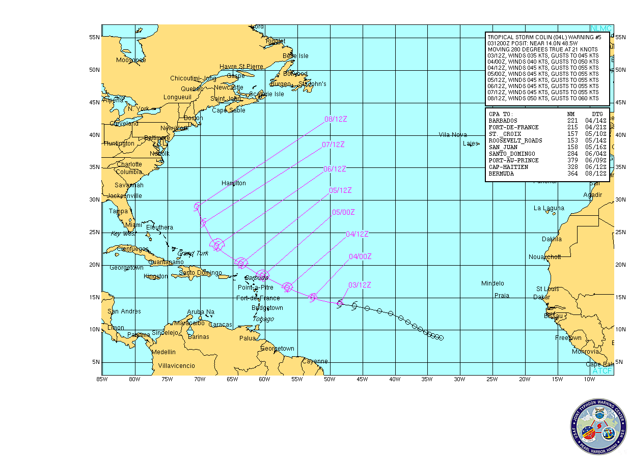
As tropical cyclones go, this is a small one, but it is a named storm, it is moving towards the west and, however low the possibility is, it could increase to hurricane strength. It is way too early to give any kind of confident forecast on this system, however, if this follows the typical re-curving track of tropical Atlantic cyclones there is the very slim possibility that Colin could pay a visit to Nova Scotia should it go extra-tropical.
All of that, however, is speculation. The NHC official discussion on Colin is that it has become very ragged and there is some question as to whether there it still has closed circulation.

Most of the intensity models do not suggest that Colin will intensify greatly over the next 48 hours, however, it is currently in an area of low wind shear and very high sea surface temperatures. The possibility of Colin encountering increased wind shear along its forecast track is very high.

This is one to watch. (As always, click on any image to enlarge)
Saturday, July 24, 2010
Bonnie downgraded to Tropical Depression

Bonnie is now downgraded to a Tropical Depression with surface wind speeds estimated at a sustained less than 30 knots (56 kmh/35 mph).

The cyclone is encountering 25+ knots of wind shear and is drawing in dry air from the southwest. It is being steered a little more south of the forecast track at about 15 knots tracking west-northwest. That should give it landfall at around 25/0400 UTC on the coast of Louisiana. There will likely be small areas of high winds in isolated squalls. In the area of the Gulf oil blowout this system, with timing and a bit of luck, should have less impact than the effects of Hurricane Alex.
The NHC has removed all Tropical Storm Warnings and added an interesting comment:I have to admit to joining a certain chorus of forecasters who viewed those intensity models with much skepticism.
WE HAVE TO GIVE CREDIT TO DYNAMICAL AND GLOBAL MODELS THAT ALL ALONG FORECAST THE CURRENT WEAKENING TREND OF BONNIE.
Wednesday, July 21, 2010
Invest 97L. A 50 percent chance of becoming a "Bonnie"

This should set the oil spill clean-up and disaster management crews in the Gulf of Mexico on their heels. This is Invest 97L, currently a significant tropical wave creating cloud, showers and high winds over the Caribbean island of Hispanola.
Right now, it's not all that organized and doesn't present much of a threat. However, as it moves westward, it will encounter reduced wind shear and very high sea surface temperatures. There is about a 50 percent chance of it developing into a tropical depression by as early as Friday morning. (Click on the picture for full size. It will make more sense then.)
Labels:
hurricanes,
tropical depressions
Thursday, July 15, 2010
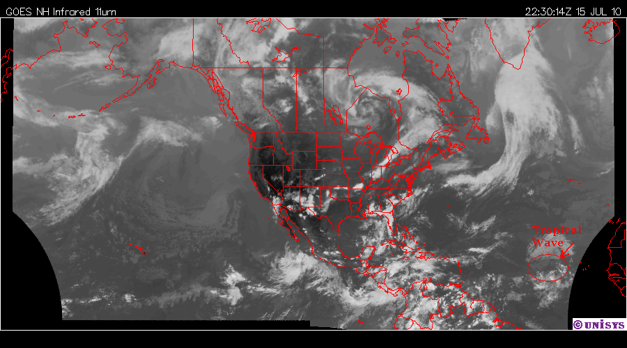
Hmmm. If I were cleaning up the worst oil spill in history...
In the Gulf of Mexico, I would be keeping a real close eye on this rather large tropical wave off the Cape Verde Islands.

They wanted a weeks notice? There's their friggin' week.

They wanted a weeks notice? There's their friggin' week.
Labels:
hurricanes,
tropical depressions
Monday, June 28, 2010
Alex back in warm water... and growing.

Alex emerged from the Yucatan intact and with enough organization to quickly regenerate. While it had been downgraded to a Tropical Depression over the Yucatan, it is now back to Tropical Storm and the expectation from both guidance models and forecasters is that Alex will spin up to a Hurricane sometime before it makes its next landfall.
The question still remains, where will Alex make landfall and how much effect will it have on the oil blowout off Louisiana. (And should the containment effort be interrupted because of a possible hurricane?)
Based on models and forecasts, the probability of Alex plowing through the oil spill is very low. That doesn't mean there won't be some effects felt in that area. Significant winds, seas and swells will have the effect of blowing the surface oil towards the coast.
The area of low wind shear, high sea surface temperatures (29.5 C) and high mid-level moisture all suggest Alex has the necessary conditions to fuel it further. Models present a wide range of possible landfalls from north of Corpus Christi, Texas to Tampico, Mexico. For the next 48 hours Alex is expected to continue a slow North West movement as it intensifies.
I'm keeping an eye on the ocean buoy (42055) in the Bay of Campeche over the next day or so.

I'm also watching the weakening ridge over the central US. If two of the models are correct, further weakening will have the effect of steering Alex poleward.
Sunday, June 27, 2010
Alex. Landfall in Belize.

Tropical Storm Alex made landfall at just after 2300 GMT yesterday. The movement slowed slightly and, as expected the storm lost intensity. It has been downgraded to a Tropical Depression for the time being. It dropped large quantities of moisture on Belize and the surrounding environs.
A good description of the passing of Alex through coastal Belize is provided by the Cay Caulker website where the writer describes the rapidly changing weather.

Alex will soon leave the Yucatan behind and enter the Gulf of Mexico. What happens after that is currently a guess. The high sea surface temperatures and low wind shear will give Alex renewed energy and reintensification to Tropical Storm status and possibly into a hurricane. Everything now depends on how much the storm slows once over water and how long it stays there.
Right now there is a ridge of high pressure north of Alex which would have the effect of causing the storm to alter to the west and make an eventual landfall on Mexico's east coast. A good number of computer models are providing that forecast guidance, however, there are some models and model ensembles which have the ridge weakening enough to cause Alex to recurve poleward and toward the northern reaches of the Gulf of Mexico.
At this point a high confidence forecast is going to require a later-in-the-day model run with more atmospheric data. That underscores another point of contention.
On at least two U.S. television stations the personalities reading and pointing at the weather conditions made statements to the effect that Alex had made landfall well to the south of the Gulf of Mexico and that all danger of the storm becoming involved with the oil blowout in the Gulf had now passed. Nothing could be further from the truth.
A majority of tropical storms which make landfall on the Yucatan survive and continue to present a threat with a large percentage of them strengthening to hurricanes. As the US National Hurricane Center states in its forecast discussion:
ALL OF THE MODEL UNCERTAINTY WITH THE TRACK OF ALEX OFFERS AI suspect the forecaster at NHC added that statement to the discussion because of the unsubstantiated conclusions being reached by US media broadcast personalities.
REMINDER TO NOT TO FOCUS ON THE EXACT FORECAST TRACK...PARTICULARLY
IN THE EXTENDED PART OF THE FORECAST PERIOD...WHERE AVERAGE
FORECAST ERRORS CAN BE 200 TO 300 MILES.
Alex remains a danger and at present we have no conclusive idea as to where it will end up.
Friday, June 25, 2010
Tropical Depression ONE ...
... is forecast to become a Tropical Storm by Saturday morning. If that happens the first named tropical cyclone in that area will become Tropical Storm Alex.
We'll have to wait to see what happens over the next few hours. Jeff Masters has a great history of past systems which developed in a similar fashion.
Most forecast models have this system crossing the Yucatan, increasing in strength but passing west of the oil blow-out area. Right now the concern is the amount of moisture this system will drop (and has already started to drop) on the coastal areas of the Yucatan Peninsula, Belize and Nicaragua.
We'll have to wait to see what happens over the next few hours. Jeff Masters has a great history of past systems which developed in a similar fashion.Most forecast models have this system crossing the Yucatan, increasing in strength but passing west of the oil blow-out area. Right now the concern is the amount of moisture this system will drop (and has already started to drop) on the coastal areas of the Yucatan Peninsula, Belize and Nicaragua.
Labels:
tropical depressions
Wednesday, June 16, 2010
Early sign of an ugly season

That... is Invest 92L. (click to enlarge) Luckily it weakened by late afternoon due to increasing wind shear. However, this is early in the season - very early. This little storm came close to reaching tropical depression status and both its formation and location have set off alarms in hurricane and cyclone warning centres around the Atlantic basin. As Dr. Jeff Masters says:
It's very rare to have a development like 92L in that portion of the tropical Atlantic this early in the season. The lower than average wind shear and higher than average SSTs that helped 92L get organized are more likely than not to carry over into the main portion of hurricane season, giving us a much more active hurricane season than normal.Quick non-technical primer.
Wind shear measurement is the strength of the upper horizontal winds. If wind shear is low it allows the depression to gain strength. If wind shear is high it takes the top off the rapidly rising air well before it reaches the tropopause and squelches storm development.
SST is sea surface temperature. High SST results in rapidly rising air creating a low pressure centre which, if conditions are suitable, can result in a rotating tropical depression.
There is a lot of debate over what will happen in the Gulf of Mexico if one of these little units develops, moves over the spreading oil and then makes landfall. Jeff Masters' prog on the subject is worth reading.
It's looking now like we're possibly going to find out sooner rather than later what will actually happen.
Subscribe to:
Posts (Atom)